Writing Comparative Reports: An Example of a Teaching and Learning Sequence
The following extract is taken from PETAA book, Put it in Writing: Context, text and language, written by Joanne Rossbridge with Kathy Rushton.
This teaching and learning sequence was developed in the context of teaching Geography. The writing focus is on writing comparative reports comparing geographic features of countries in different continents such as Australia, Africa and South America. This requires knowledge about countries located in similar climate zones and their natural vegetation. This is addressed within the context of ‘knowing and understanding how the Earth sustains all life’ (ACARA, Year 4, 2015).
In this example, the text deconstruction is based on a comparative report comparing the features of the Daintree and Amazon rainforests. Knowledge about text and language is then applied to writing a comparison of the Kalahari Desert in Africa and the Great Victoria Desert in Australia.
Much field knowledge is required to compose such texts in terms of locating and organising information and features on a number of countries. Students can obtain information on environmental entities through many websites. However, accessible models of comparative reports tend to occur on travel sites or sites which share research across communities (e.g., Wikispaces, eHow, answers.com, prezi, etc). These types of sites support developing field knowledge and serve as an induction into geographical thinking. They also provide models for discussing text structures and features of a range of informational texts and can be used as a medium for publishing and sharing research. Examples of some such sites for investigating forms of comparison of these rainforests are included in the Resources section of this model.
It should be noted that when engaging with the field in order to locate facts, many visual sources such as graphs, tables, photographs and a variety of maps are useful for gathering geographical information.
Summary of a Teaching and Learning Cycle
Building the Field
- Use a globe and Google Earth to identify the continents of Australia, South America and Africa. Record countries within the continents on a map.
- View map of the world in the MapMaker Interactive (National Geographic) and display climate zones. Students can predict the type of environment and climate that might exist across the continents and what type of life might be found. Point out countries and regions located at similar latitudes.
- Place a piece of string around the globe and identify places which may have the same climate zone based on their latitude and particularly the equator and arctic poles.
- Locate possible places that might be similar and record on cards. Search for pictures showing what each place might look like.
- Classify into types of vegetation/environment, eg, rainforests, deserts, alpine, grasslands, tundra etc.
- Watch videos and read a range of texts on the range of places and vegetation.
- Using the Venn diagrams, Prezi or Popplet programs, record information on two places to show how they are similar or different, eg, Amazon and Daintree Rainforest/Kalahari and Great Victoria Desert, Andes and Snowy Mountains. This information can also be organised into a table (detailed table example provided in Put it in Writing).
- Compare facts from different sources and investigate the authority of the authors.
Text Deconstruction/Modelled Reading
- Read examples of descriptive reports on the Amazon and Daintree Rainforests.
- Display the text The difference between the Amazon and Daintree Rainforests and ask the students to identify how it differs from the descriptive reports.
- Discuss the purpose and intended audience and who would write such a text.
- Identify stages and phases and note how the stages are similar to descriptive reports but the phases differ due to the comparison of entities. In small groups students can categorise paragraphs from both descriptive and comparative reports and begin to identify differences in language features.
- Model highlighting words which build the comparison and link features of the two entities together. Discuss the relationship to the text stages and phases.
- Categorise the cohesive devices in a table. Students might repeat this with another comparative report, eg, The difference between the Andes Mountain Range in South America and the Snowy Mountains in Australia, and add additional words to the table.
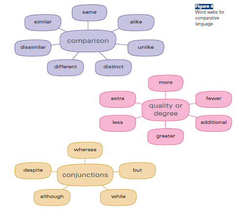
- Create word webs to display word groups which make links across the text (see below).
Joint Construction
- Display a draft comparative report which requires editing for cohesive devices.
- Draw on word webs to jointly rework the text through use of comparative adjectives and conjunctions.
- Highlight and evaluate the use of cohesive devices to compare the draft with the reworked text.
Independent construction
- Based on information recorded on the Venn diagrams, Prezi or Popplet programs, students select two places to compare. From a Venn diagram or Popplet students might represent their information and publish on Prezi to plan for writing.
- From this information students draft their own text either individually or in pairs.
- Students highlight their use of comparing adjectives, intensifiers and conjunctions that help the text achieve the purpose of comparing. Encourage students to check that these features are present across the whole text.
- Students redraft their text with a focus on cohesive devices.
- In small groups students share their texts and discuss the changes they have or have not made.
- Students can then make any further changes based on peer feedback and publish in school blogs, Wikispaces or other sites where knowledge is shared in a community.
Word webs for comparative language: